Mapping The Extent Of NRL’s Encroachment In Assam
Author:
First published in Sanctuary Asia,
Vol. 35
No. 10,
October 2015
Photo Courtesy: Rohit Choudhury.
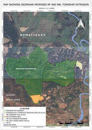
This maps shows the boundaries of the Deopahar Reserve Forests, the adjoining, forested hills of Kalyani Pahar, the existing Numaligarh Refinery Ltd. (NRL) township, the site of the proposed new township, the location of the golf course and also, the boundary wall around it. These boundaries were overlaid via Google earth imagery in order to show the forest cover. The GPS coordinates are also depicted in the maps.
The new proposed township area is located on the western side of the old township, and across the elephant corridor. A boundary wall, about 1.5 km. long and 4.5 m. in height was constructed around this land during 2011 by NRL. This is the wall that obstructs the route of the elephants.
In the past, the elephants have broken portions of boundary wall, and crossed streams to regain access to their blocked foraging site.
Read more: Wildlife Laws Violated, Elephant Corridor Blocked In Kaziranga Landscape
View the plight of the pachyderms at: https://youtu.be/f4Dzkr5cz8c